 Go up
Go up


Exploring SimplyMap Data: America’s Historic Homes
Posted on Jan 07, 2015 by Admin
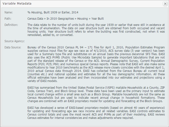
In this week’s exploration of SimplyMap data, we set out to find which cities in the United States have the highest percentage of older houses. To determine this, we used the variable “% Housing, Built 1939 or Earlier”. The metadata for this variable is shown below:
The ranking report allows SimplyMap users to analyze the data by different geographies. For example, if you select the United States as your location, you may rank the data by: USA, States, Congressional Districts, Counties, Cities, ZIP Codes, and Census Tracts.

First, we’ll take a look at the top 10 states. For reference, 12.71% of all of the housing stock in the USA was built before 1939.
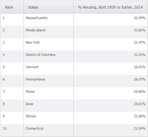
Not surprisingly, the majority of the states with the highest percentage of older homes are located in the northeast. When we switched to cities and applied a population filter > 50,000 we were left with the following cities:
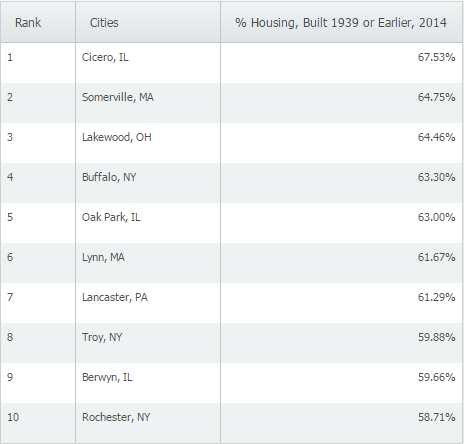
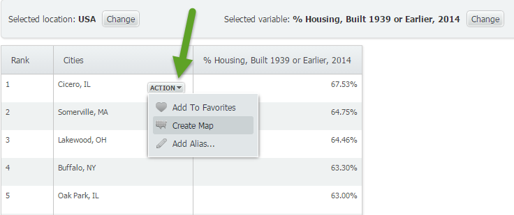
At 67.53% of homes built in 1939 or earlier, Cicero, IL ranks first among cities with populations greater than 50,000 in the United States. We then used the feature to make a map directly from the results page by hovering over Cicero, IL and selecting “Create Map” from the action drop down.
It looks like Cicero, IL is located about 10 miles west from the heart of Chicago.

Want more tips and examples of SimplyMap reports? Follow us on Twitter and like us on Facebook to stay informed!
More from SimplyAnalytics


Posted on Apr 18, 2017 by Admin
We look forward to attending the Texas Library Association Conference this week in San Antonio and visiting with the library community. Stop by our new SimplyAnalytics booth (2029) and ta...
Posted on Oct 16, 2015 by Admin
Did you know that SimplyMap includes the ability to export Shapefile data for use in desktop mapping software (such as MapInfo or ArcGIS)? This advanced feature extends the power of Simpl...
Posted on Jun 01, 2014 by Admin
Visit the SimplyMap team at the ALA Annual Conference and Exposition in Las Vegas later this month. We will be at booth 1271, offering product demonstrations, tips & tricks, and of co...
Posted on Jan 24, 2009 by Admin
Men's Health magazine took a look this month at where our wireless habits are most out of control. Their methodology includes the use of SimplyMap: First, we crunched data from SimplyMap...
Posted on Nov 24, 2014 by Admin
In this week’s report, we research America’s most educated cities. SimplyMap contains a total of 111 educational attainment variables, including general population and by race. We used th...
Posted on Jul 14, 2009 by Admin
Men's Health continues to utilize SimplyMap to identify and rank U.S. cities. This time they are studying "sports-obsessed citizenry," and here is how they did it: Our stat showdown began...
Posted on May 26, 2020 by Admin
Hello readers! We hope you are doing well, and thank you for your continued support of SimplyAnalytics. We are excited to announce that scatterplots are officially live! Scatter plots ar...
Posted on Feb 27, 2009 by Admin
Geographic Research, Inc. is pleased to participate in the Statewide California Electronic Library Consortium's (SCELC) 12th Annual Vendor Day. SCELC members and librarians from other aca...
Posted on May 16, 2022 by Admin
Hello readers! We hope you are having a wonderful day. Today we feature a question from the help desk that we think many users would find useful. Let’s get started. The question: How can ...
Posted on Dec 03, 2015 by Admin
With the Thanksgiving holiday last week, we decided to take a quick look into SimplyMap to see what pertinent variables are available for analysis. First, open the Variables panel and cli...